Latest Evolution (Year 2020 and Beyond)
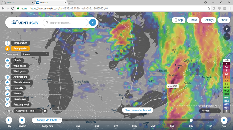
 ISWMS™ (Version ‘2’) is a fully functional web-based / open source GIS system for forecasting and visualizing flood extents in watersheds anywhere in Canada. ISWMS™ (v.2) automatically gathers Environment Canada open climate forecast databases (deterministic) and feeds them into sophisticated and computationally demanding hydrologic and hydraulic models to develop deterministic forecasts of water levels and inundation.
ISWMS™ (v.2) is deployed on a cloud (but is executed in serial-mode) and runs periodically (within hours) to develop flood forecasts for interactive web-based visualization and flood mitigation decision support. Also, given the Platform’s integration with HEC-HMS (hydrologic) and HEC-RAS (hydraulic) analytical models, ISWMS™ (v.2) has these unique attributes to:
 In January 2020, and part-of a multi-year software collaboration, GREENLAND® and University of Guelph (Canada), began the development of the next IoT Platform version of ISWMS™.
This research intends to develop a modeling extension that will allow ISWMS™ (v.2) to: 1) run efficiently on parallel compute clusters; and, 2) incorporate uncertainties associated with climate forecasts into flood extent forecasts of ISWMS™. This ISWMS™ Version ‘3’ is also referred to as “ISWMS™ - Smart”. Our team has also successfully leveraged parallel computing (via a prior project for CANWET™ and with deployment on a Cloud Analytics Platform) in developing an efficient web-based platform for calibration of hydrologic models. Our team intends to build upon this niche expertise and knowledge attained in the past software collaborations and to develop the first ISWMS™ - Smart prototype in 2020.
ISWMS™ - Smart will quantify any uncertainties in ISWMS™ (v.2) flood forecasts originating from the uncertainties inherent in the climate forecasts, by enabling ISWMS™ to run in parallel for different climate forecast scenarios. Therefore, a critical need for successful development of ISWMS™ - Smart is the development and testing of a parallel programming infrastructure for ISWMS™ to improve its efficiency. Consequently, the research pertaining to development of ISWMS™ - Smart requires continuous access to compute clusters designated for developing innovating computing solutions to complex problems. Moreover, ISWMS™ - Smart will include AI-based (machine learning) algorithms designed to optimize the use of computing resources during parallel runs of any ISWMS™ - Smart hydrologic and hydraulic models. Hence, secure (continuous) access to advanced computing resources will also be implemented to confirm the effectiveness of the new algorithms. This will also be key for future contractual partnerships too.
Spatial-temporal resolution and complexity of earth data and human-environment interactions is continuously increasing, and demanding an improvement in complexity and efficiency of flood forecasting decision support systems. ISWMS™ - Smart will significantly improve the capability (by quantifying forecast uncertainty) and efficiency (via parallelization) of ISWMS™, allow the ISWMS™ decision support system to run on large watersheds, and consequently increase the applicability of the platform for new clients. Moreover, the computational efficiency of ISWMS™ - Smart also intends to reduce operational costs (of cloud computing services). Therefore, this next evolution of ISWMS™ will also be a “disruptive market advantage” for GREENLAND®.
ISWMS™: Background (2000 - 2019)
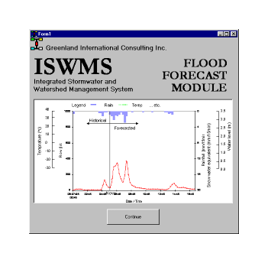
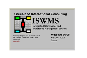 In 2000, the first Integrated Science and Watershed Management System (ISWMS™) tool was completed by GREENLAND® as a windows-based ‘SWMM and OTTHYMO’ – based decision support system for urban land stormwater management; hydrological (continuous rainfall and design storm events) modelling; and, Canadian flood forecasting capabilities.
 In 2003, GREENLAND® was retained to develop ISWMS™ (Version ‘1’) as a flood forecasting system for the 3,360km² Nottawasaga River Basin, located north of Toronto (Canada). It was then used for many years thereafter to prepare Subwatershed Management Plans in Ontario. In 2006, GREENLAND® began working on the next ISWMS™ (v.1) phases, including an open source GIS operational platform that was developed for a daily water balance, nutrient and sediment loading tool (CANWET™).
In 2010, the ISWMS™ program added new technical support partners affiliated with Canadian and U.S. universities. These independent scientists would later on assist GREENLAND® as a “science advisory team” for engineering projects that also used the company’s in-house tools.
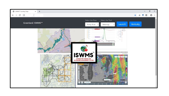 In 2016, GREENLAND® formed a strategic alliance in Europe with private and public sector teams from Sweden and France and to initiate a new IoT Platform partnership. The initial goal was to develop a cloud-based flood forecasting, flood control and floodplain mapping system (called ISWMS™ - Version ‘2’) for watershed managers and regulatory agencies. The first collaboration was completed in 2019 and where the new web-based tool is being used now in Canada to identify real-time solutions that can minimize mixed rural & urban watershed flood damages and help prevent loss of life from flood disasters. This platform was also developed for use anywhere else in the world. It includes an early warning flood forecasting system that requires powerful visualization connected to the latest (public domain) versions of HEC-HMS and HEC-RAS that are developed /maintained by the U.S. Army Corps of Engineers.
Development of the ISWMS™ Platform relied on other proprietary GREENLAND® hydrology and stormwater management modelling tools. The GREENLAND® (Canada-Europe) team consulted also with property-casualty insurers in order to develop an open/transparent system framework that could also address climate impact concerns. Other Canada-based partners included the County of Simcoe (Ontario); University of Guelph; Communitech Corporation; First Nations; and, University of Waterloo Interdisciplinary Centre on Climate Change (IC3) and Partners for Action (P4A) network. Finally, the U.S. software engineering firm ‘Civil-GEO’ was consulted on the project too. In late 2019, the GREENLAND® team (and also with the University of Guelph) secured new leverage funding to continue the ISWMS™ IoT Platform development program. In the meantime, GREENLAND® continues to use ISWMS™ (v.2) as a “free licensed asset” for its consulting client contracts (private and public sectors), and for new collaborations supported by Canada’s National Flood Damage Reduction Program, as well as future Smart Cities & Climate Change Adaptation - Protection Programs.

County of Simcoe
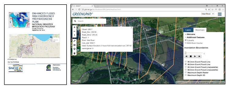
The County of Simcoe is the upper tier government and planning authority for most of the South Georgian Bay – Lake Simcoe Source Water Protection Region. The County, in partnership with its member municipalities, other levels of government, floodplain management agencies and two (2) conservation authorities, also provides leadership through policy, and actively in the restoration and protection of the environmental health and quality of these watersheds. As you know, in order to comply with, and be environmentally proactive with respect to the Province of Ontario’s “Places to Grow” legislation, the County of Simcoe utilized innovative decision support tools such as Greenland’s CANWET™ model. In 2012, CANWET™ was also used by the County to prepare a “Water and Wastewater Infrastructure Visioning Strategy”. To this day, the information in the Strategy’s final report is used by local municipalities, development interests and other stakeholders as a background reference to help identify sustainable development solutions.
This letter confirms the County of Simcoe's commitment of support which includes initially facilitating the introduction of this landmark international collaboration with all 16 local municipalities, other governments (small and large) and other agencies that partner now with the County of Simcoe on land use planning; infrastructure renewal; and flooding risk/damage reduction initiatives.
As always, I look forward to our continued working relationship with you and your colleagues and the significant benefits these efforts will have for our residents and environment. The County of Simcoe appreciates your efforts towards developing information based decision making tools and we are confident that this project will prove beneficial in our collaborative goal to improve watershed health for all County residents.
Mark Aitken
Chief Administration Officer
The Corporation of the County of Simcoe
October 19, 2015
The City of Waterloo
As a Senior Project Engineer (Water Resources) for the City of Waterloo, I would like to extend my appreciation to Greenland Consulting Engineers for providing exemplary EA planning, design, contract administration and construction inspection services for the Pond #53 Sediment Removal/Reuse and Retrofit Project.
This project was an important undertaking for the City which consisted of: the removal of 360m3 of sediment for reuse in a City owned boulevard area; removal of all additional sediment (approx. 3,000m3) from the SWMF permanent pool and forebay area to improve its operation, implementation of the retrofit design including improved maintenance access and proactive management of many unforeseen conditions throughout the duration of the project. This project also included significant logistical challenges with respect to the coordination of public access for area residents and businesses, and providing workable solutions to implementing the design as intended due to challenging unforseen site constraints.
As the Design Consultant, Contract Administrator and on-site Construction Inspector, Greenland always maintained open lines of communication between the City, Contractor and the affected residents, and promptly responded to all questions and issues raised by the Contractor, the City and the public. Greenland’s attention to detail throughout the entire duration of this assignment helped ensure the project was completed as required.
Jessica Kellerman, P. Eng
Senior Project Engineer - Water Resources
Engineering Services, Design & Construction
City of Waterloo
October 24, 2019
City of Greater Sudbury
Re: Capreol Downtown Waterfront CIP and Whitson River Waterway Trail
The City of Greater Sudbury has used the services of Greenland International Consulting Ltd. for the design of the Capreol Downtown Waterfront and the design of the Whitson River Waterway Trail.
Greenland delivered both projects on budget and provided consistency in its leadership from the landscape team. This stability in project management meant that we were working with a company who was familiar with the City’s project and consultation processes.
The Capreol Downtown Waterfront improvements were constructed in 2018 in time for the community’s 100th anniversary and incorporated the community’s railway history into the design. Greenland was skilled at integrating the wishes of the community into cohesive and creative designs that provide great connections between the Community’s main street areas and natural features.
Melissa Riou, MCIP, RPP
Senior Planner
Community and Strategic Planning
Growth and Infrastructure Department
City of Greater Sudbury
December 23, 2020