 CANWET™ is an open data, urban and rural, platform (and developed by GREENLAND® since 2003) for cumulative effects analysis and watershed management. CANWET™ is now “Powered by SWAT” and includes open source GIS-software designed to inform decision making around watershed management; integrated water supply and wastewater treatment infrastructure; urban drainage control; and, climate change adaptation. The platform’s ability to accurately calculate hourly water balance, nutrients, erosion sediment, bacteria, water temperatures, dissolved oxygen and other parameters from GIS data, enables CANWET™ to serve as a powerful decision support system. It also includes science-based climate change impact and mitigative Best Management Practices & Low Impact Development analytics, as well as “automated” modelling data calibration and verification capabilities.
The initial versions were completed with support from the Province of Ontario (Canada) to develop the award-winning “Lake Simcoe Protection Plan”. Further tool updates were then used for similar Assimilative Capacity; Watershed Planning; Master Drainage Planning; Water and Wastewater Infrastructure Planning; and, Source Water Protection projects in Canada.
From 201 5 - Present, GREENLAND® and the University of Guelph (Canada) were retained by the Government of Canada to undertake an “Evaluation of Policy Options to Achieve Phosphorus and Nutrient Reductions from Canadian Sources to Lake Erie”. The initial project established an extensive list of the most viable policy options. Subsequent evaluations then examined the effectiveness of all policy options on the basis of achieving nutrient load reduction targets; sustainable cost effectiveness; potential impact to the economy; social acceptance; and, efficiency of implementation. Later projects then considered what initiatives were in place and recommended how gaps might be filled. The main objective was to determine what “best suite of policy actions” could achieve the greatest nutrient load reductions, while also being the most effective in terms of cost, time and social acceptance. A unique analytical and stakeholder engagement approach was undertaken using CANWET™ (v.4) and as a means of quantifying and better understanding the origin / timing of phosphorus loads from the Canadian watershed lands draining to Lake Erie.
 In 2018, GREENLAND® initiated a 4-year software collaboration with the University of Guelph (Canada). The first project included further developing CANWET™ with Artificial Intelligence (machine learning) features, as well as maintaining current capabilities and adding new / proven-science predictive modelling functions available for the “SWAT” analytical engine. “The system will make this information accessible to everyone from government to urban planners and researchers,” says Professor Prasad Daggupati from the University of Guelph. “Users will be able to see spatially what is happening and take appropriate actions.” The project will enable regulatory agencies to reduce the harmful effects that algal blooms have on water quality, fish, and wildlife populations in and surrounding the Great Lakes Basin.
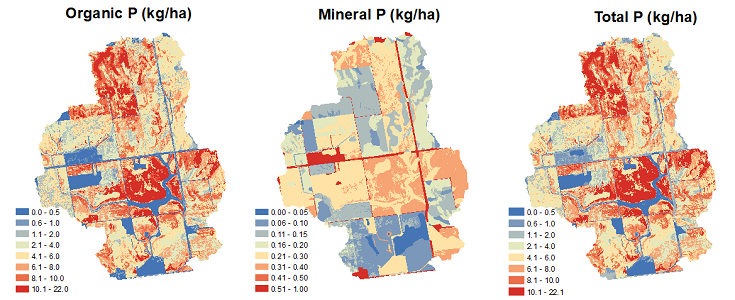
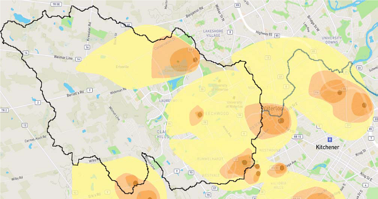
CANWET™ Spatial (HRU Scale) Distribution of Annual Average Phosphorus Forms (Organic, Mineral, Total at the “Site Level”) in a Subwatershed of the Grand River Watershed (Lake Erie Basin – Canada)
The latest “Big Data Version” of CANWET™ (developed by GREENLAND® and University of Guelph) has advanced earlier (desktop) versions by utilizing high performance parallel (cloud) computing functionality. The latest update is a fully functional web-based platform with SWAT modelling tools that can allow greater access by decision makers and stakeholders. Therefore, the new version advances the idea of evaluating cumulative effects in the watershed decision making process rather than the current practice of assessing proposed changes in isolation.
The CANWETTM evolution (since 2018) has taken advantage of high performance computing by porting existing code to a higher performing language and restructuring to operate using parallel or multi-core processing. Therefore, the platform operates now with “dramatic reductions” in simulation runtimes. The reduced runtimes also facilitated the use of new automatic calibration and verification routines for SWAT model setups – thereby, reducing project labour costs. It can also enable faster analytics for “What-If” watershed simulations and if a re-run is requested through the web-based user interface. In 2021 (and beyond), it is anticipated the CANWET™ (machine learning) web-based platform (“Powered by SWAT) will be used more by decision and policy makers in Canada and to understand better the sources of pollution (and related climate change factors). For example, this includes phosphorus which is a major contributor to Lake Erie eutrophication problems. Therefore, CANWET™ can be used to also develop sustainable policies in supporting a wide variety of watershed planning Best Management Practices and ultimately help achieve the Canadian Government’s commitments to reduce 40% phosphorus entering Lake Erie by 2025.
 In January 2020, another CANWET™ public – private partnership involving the City of Waterloo (Canada) was initiated by the GREENLAND® and University of Guelph team. This collaboration will develop an integrated model of surface/groundwater interactions using CANWET™ and with available “MODFLOW” databases. The platform will be used by the project team to investigate sodium chloride (salt) transport affecting the Laurel Creek Watershed. The integrated surface / groundwater platform will also take advantage of in-house high performance computing resources to calibrate and validate the CANWET™ model. This second-to-none platform will enable the Municipality to:
______________________________________________________________________________

Communitech
The Greenland Group (Greenland) was introduced to Communitech in 2013. This letter is to acknowledge the importance of this proactive joint venture and to indicate our strong interest in future project partnerships with Greenland and other network members.
Greenland is now supporting other joint initiatives with Communitech. These leading-edge information technology partners will include other private sector members with the Communitech network, as well as Ontario government agencies and First Nation communities. These projects are intended to develop commercialized products and services involving the Greenland Group and other Communitech partners and to enable new Canada-wide related collaborations.
Mark, if any your prospective clients or contacts have questions regarding our collaborative efforts to date, ongoing discussions and project leveraging capabilities, the Communitech team would be more than happy to help.
We look forward to our continued strong collaboration with Greenland.
Iain Klugman
CEO
Communitech
February 19, 2015
City of Ottawa
On behalf of the City of Ottawa, we would like to thank Greenland International Consulting Limited, and in particular, Don Moss for his exemplary efforts in his role as Model Keeper for the City of Ottawa… Greenland has achieved a high level of confidence with Senior Staff and City Council as well Conservation authority and the Ontario Ministry of Environment… The City is appreciative of the new Modelling Tool developed by Greenland which will assist the City in conducting timely and efficient development reviews. The City will now be able to test proposed infrastructure with the overall development, determine changing impacts to existing infrastructure as ponds, as well as any changes to the receiving watercourses.
Don’s knowledge, dedication and professional approach over the past five years has been a crucial factor in the success of the project under very challenging circumstances.
Don Herweyer, MCIP, RPP
Program Manager
City of Ottawa
February 11, 2014
Six Nations Council
On behalf of the Environment Office of the Six Nations of the Grand River, we would like to thank Greenland International Consulting Limited for the work completed to prepare the Master Drainage and Flood Remediation Plan (MDFRP) for the McKenzie Creek watershed. This plan has now enabled our office to identify the flood prone residences throughout the watershed with the flood plain mapping that has been prepared as part of this assignement. We appreciate the role that Greenland has played in assisting our office in directing Public Works with prioritizing the remedial projects to be completed in the flood prone areas.
We also appreciate Greenland's effort in assisting the Six Nations of the Grand River with the preparation of funding applications to secure the resources to complete these remedial works. We are convinced that this MDFRP can be used as a template for completing similar drainage and flood remediation works both locally and in other First Nations lands.
We look forward to working with your company again in the near future on the remaining watersheds that need this important work done.
Thank you for your ongoing assistance.
Clynt King
Environmental Technician
Six Nations Council Environment Office
July 25, 2016